Wimble Scale: Difficult, Length: 5.3 miles, Climb: 1800 feet, Time: 3.5 hours
This Saturday, February 28, is a new hike for most of us, including me -- Pinnacles National Monument.
Plan on over 2 hours to get there, at least 3 to 4 hours to hike, and more than 2 to get back again - this is going to be a long day with lots of hard hiking.
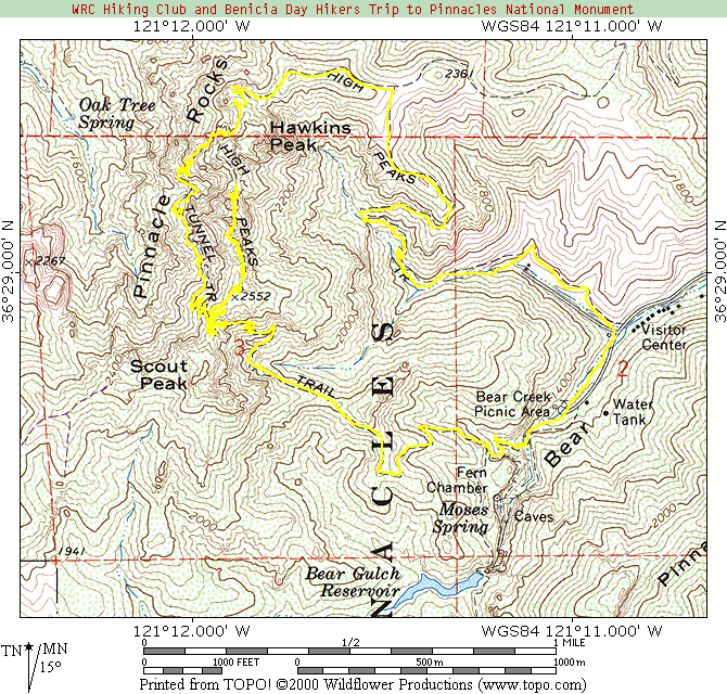
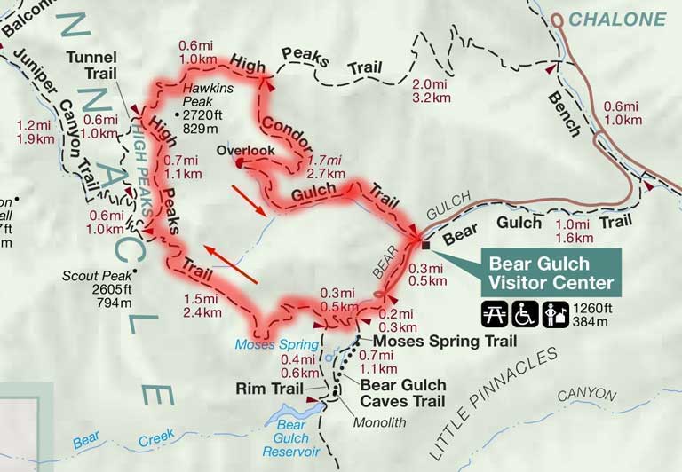
Look at http://www.mtycounty.com/pgs-parks/pinn.html for a partial map of getting there and the hiking trails. We'll be coming in from the East Entrance. We'll make the actual trail plan once we get there, take advice from those who know the area, and see what things look like.
Bring a flashlight. Some of the caves require a flashlight, some are easily flooded and may be closed. It looks like some people may not want to navigate the caves as some of them require scrambling through tight fits.
Bring waterproof shoes, as some trails have on order of 6 stream crossings without bridges. NO SNEAKERS.
Bring plenty of water, a meal, snacks, sunblock, and layers of clothing. Be prepared for hot and cold, dry and wet.
Some pictures from other sites:
http://www.stanford.edu/group/strgeo/Pinnacles.html
http://www.pinnacles.org/gallery/index.html
http://volcano.und.nodak.edu/vwdocs/Parks/pinnacles/pinnacles.html
http://www.assimilatedmultimedia.com/Pinnacles/pinnacles3.html
A potential hiking map: http://www.wadleynet.com/pinnacles/pinnbm24k.gif
We leave here 7:30. Yes, I didn't know there even was a 7:30 in the morning. We start the hike a bit before 10, we hope. With luck, we'll leave the park by 3-ish and be back home by 6-ish, depending on if we stop for eats on the way back.
Some driving instructions from another web site:
Take Highway 101 South past Gilroy. Turn left onto 25 to Hollister. Follow the signs and stay on highway 25. About 30 miles south of Hollister, take a right onto highway 146. Note that you cannot access the East Side of the park from Soledad. Please, consult a map for details on how to get to the park. There is a 4-dollar access fee per car.
Kathy and I both had sore thighs the next day, but we don't know why. Sore calves, I could understand. When you see the pictures, you'll see just how steep and narrow some of the trails were. Actually, you don't really see the narrowest parts. I was nearly on my knees, banged my elbow, and scraped my backpack trying to get through one of the passes.
We believe we saw condors. We definitely saw vultures, falcons, hawks, and woodpeckers. The squirrels down by the visitor's center were extremely friendly. Kathy did her squirrel call and had them flocking near her.
Dinner at the Black Bear restaurant in Gilroy was also great. A perfect ending to a perfect day.
 |
|