Montebello Ridge
Description
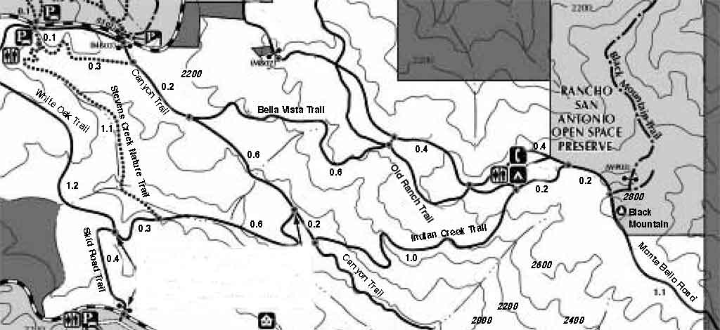
The Monte Bello Ridge area spans the area from Stevens Canyon in Cupertino to Page Mill Road in Palo Alto. The immediate ridge area offers easy to moderate hikes along the exposed ridge line. There a plenty of views into the Santa Clara Valley and into the Stevens Creek Canyon. You can see from Los Gatos to San Mateo on the north side, and to the ocean on the south side. There are also connecting trails that will take you down to Rancho San Antonio, up to Skyline Boulevard, or down to the end of Stevens Canyon Road.
The ridge trails are a combination of wide access roads and narrower single track trails. Almost all of the trails are exposed, though the Stevens Creek Nature Trail loop offers some amount of cover.
A common hike from the Page Mill entrance, to the back pack area and back, is a four mile out-and-back hike with about 500 feet of climb out and descent back.
The Stevens Creek Nature Trail loop beginning at the Page Mill entrance is about 3 miles with about 500 feet of descent out and climb back.
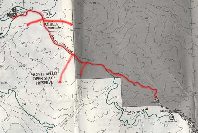
You can also hike the ridge beginning at the end of Montebello Road, which begins near the Stevens Creek Reservoir. From the end of the road, the easy hike to the back pack area and back is about 4.6 miles with about 400 feet of undulating climb.
If the weather is not too hot, one or two small water bottles will suffice for the above hikes. In the hottest part of summer, the exposed ridge is very hot. Take extra water then.
The trails are free of poison oak, except for those portions that go under cover, such as the Stevens Creek Nature Trail, or the Canyon Trail down to the end of Stevens Canyon Road. Even on these trails, the trails are well travelled and it is easy to avoid the poison oak.
Directions
From Palo Alto, take the very curvy Page Mill Road. About 7 miles west of Interstate 280 and little more than half a mile before the summit at Skyline Boulevard, you will find the entrance to the Montebello Open Space Preserve on the south side of the road. This is the normal entrance to the park.
For an alternate entrance to the other end of the park, from Cupertino, take the Stevens Canyon Road which begins at the intersection of Foothill Boulevard and Stevens Creek Road. As you round the Stevens Creek Reservoir, take a right onto Montebello Road. There is very limited parking at the end of the long, curvy road -- only room for 3 or 4 cars.
Click on the map below for a larger, higher quality map.
See also
The Midpenninsula Regional Open Space District page is at http://www.openspace.org.
The Bay Area Hiker has a description at http://www.bahiker.com/monte.html.