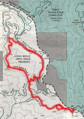
Long Ridge Open Space Preserve
Description
A favorite hike of ours. Half is covered with switch backs, stream crossings, and passing by a private meditation institution. Half is exposed overlooking the valley. There is a little climbing at the beginning and the end, and lots of mostly flat terrain in between. Wild life includes turtles, fence lizards, snakes, buzzards, hawks, coyote, deer, mountain lion, turkey, and wild pigs.
This trail is moderate on the "Wimble Scale". Plan on two large water bottles on a hot day, and one snack. The hike will probably take 2 to 3 hours and will run a bit over 5 miles. There are no toilet facilities anywhere nearby, although the Saratoga Summit Fire Station is not too far away.
|
|
|
|
|
 |
Directions
- Take Highway 9 to the top of the ridge to Skyline Boulevard.
- Head northwest on Skyline Boulevard for about 1.7 miles. You will come to a small parking turnout with the Saratoga Gap Trail coming out on your right (north), and the Hickory Oaks Trail on your left (south).
- Enter the trail on the Hickory Oaks Trail. After a short climb, you can take a hike of a few dozen yards to the left for a scenic overview. Return to the intersection.
- Head northwest at the intersection. You will come to another intersection just a short way up the trail.
- Take the left trail if you want an exposed, scenic overview of the valley. Take the right trail if you want to stay under the tree cover. Both trails meet after a short distance.
- Continue northwest, mostly exposed, for a half mile to the Ranch Spring Trail intersection. You can take this 1.5 mile or longer loop, and return to the Hickory Oaks Trail.
- Continue northwest another 0.2 miles, looking out for wild turkeys, to the Ward Road trail on your right. This is a possible return path on the way back.
- Continue another 0.1 miles under cover to an intersection with Ward Road on the left and Peters Creek Trail on your right. You will be coming out of Peters Creek Trail when we complete the loop.
- Continue northwest 0.5 miles along the exposed Long Ridge Road until you come to an intersection with a private road. There is a bench where you can view the valley and the ocean (if the fog permits).
- Turn right into the trees. You will be desending. About 0.8 miles further, you will come to an intersection with a sharp turn, almost looping back onto the trail you are on. Bear right.
|
|
|
- About 0.4 miles along the trail, heading southeast, you will come to the intersection with the Bay Area Ridge Trail and a trail which could take you up to Skyline Boulevard at the Grizzly Flat trail head. Instead, continue southeast for about 0.7 miles.
- You may cross several streams, depending on the time of the season. You will eventually come to a bridge the crosses a small damn near a pond. There is a private meditation retreat to the east here with a sign noting the private property. The pond has large turtles that rest from early evening to morning on logs that have fallen into the stream.
- Cross the bridge, heading southwest, and begin a series of switchbacks and climbs which will take you in and out of cover. You should see signs of wild pigs in the meadow areas. After about 0.5 miles of climbing, you will come back to the Ward Road, Long Ridge Road intersection.
- Head south and return the way you came. If you want, however, you can take Ward Road east to Skyline Boulevard. You will have to walk along Skyline Boulevard for about a half mile, though, to get back to the starting parking spot.
|
See also
Trip Reports
Saturday, July 29, 2000
Dirk, Kathy, and Michael "do Crazy Petes Loop".
Copyright © 2000-2002 by Michael Wimble, ALL RIGHTS RESERVED